Philadelphia neighborhood map
You can find on this page the Philadelphia neighborhood map to print and to download in PDF. The Philadelphia districts map presents quarters, region, suburbs and surrounding area of Philadelphia in Pennsylvania - USA.
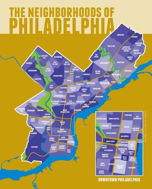
Philadelphia neighborhoods map
The Philadelphia neighborhoods map shows region and suburbs of Philadelphia areas. This neighborhood map of Philadelphia will allow you to discover quarters and surrounding area of Philadelphia in Pennsylvania - USA. The Philadelphia quarters map is downloadable in PDF, printable and free.
Philadelphia has many neighborhoods, each with its own identity. The large Philadelphia sections, North, Northeast, Northwest, West, South, and Southwest Philadelphia surround Center City, which falls within the original city limits prior to consolidation in 1854. Numerous smaller neighborhoods within the areas coincide with the boroughs, townships, and other communities that made up Philadelphia County before their absorption by the city as its mentioned in Philadelphia neighborhoods map. Other neighborhoods formed based on ethnicity, religion, culture, and commercial reasons.
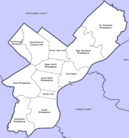
Philadelphia districts map
The Philadelphia districts map shows all quarters and suburbs of Philadelphia. This district map of Philadelphia will allow you to discover areas and the region of Philadelphia in Pennsylvania - USA. The Philadelphia districts map is downloadable in PDF, printable and free.
For planning purposes, the city is divided into 12 Planning Analysis Sections or districts, which are Center City; South Philadelphia; Southwest Philadelphia; West Philadelphia; Lower North Philadelphia; Upper North Philadelphia; Bridesburg-Kensington-Port Richmond; Roxborough-Manayunk; Germantown-Chestnut Hill; Olney-Oak Lane; Near Northeast Philadelphia; and Far Northeast Philadelphia as its mentioned in Philadelphia districts map. The Center City Planning Analysis Section extends from South Street on the south to Vine Street on the north, and from the Delaware River on the east to the Schuylkill River on the west. North Philadelphia, nicknamed North Philly, is a section of Philadelphia, Pennsylvania, in the United States. It is immediately north of Center City. Though the full extent of the region is somewhat vague, “North Philadelphia” is sometimes regarded, especially by people with little familiarity with Philadelphia neighborhoods, as everything north of either Vine Street or Spring Garden Street, between Northwest Philadelphia and Northeast Philadelphia.