

You can find on this page the Philadelphia transport map to print and to download in PDF. The Philadelphia transportation map presents the transports network and transport zones of the transit of Philadelphia in Pennsylvania - USA.
The Philadelphia transport map shows all means of transportation in Philadelphia. This transports map of Philadelphia will allow you to move easily with public transport of Philadelphia in Pennsylvania - USA. The Philadelphia transportation map is downloadable in PDF, printable and free.
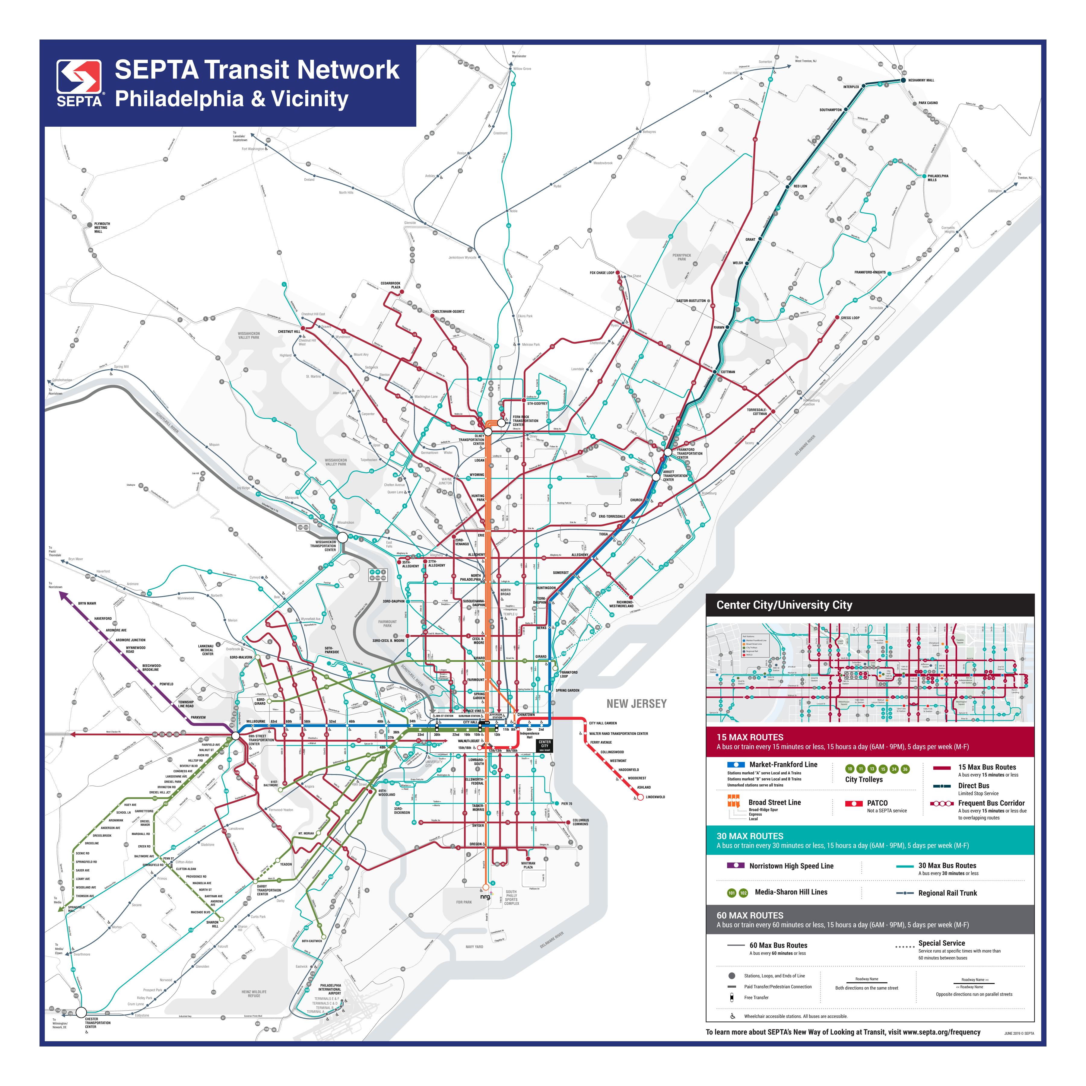
Transportation in Philadelphia involves the various modes of transport within the city and its required infrastructure. In addition to facilitating intracity travel, Philadelphia transport system connects Philadelphia to towns of its metropolitan area and cities of the Boston-Washington megalopolis. The city is crossed by the Delaware Expressway (I-95) and the Schuylkill Expressway (I-76), which are the principal thoroughfares for intercity traffic as you can see in Philadelphia transports map. The Vine Street Expressway (I-676) travels between I-76 and I-95 in Center City Philadelphia, and the Roosevelt Boulevard (US 1) carries crosstown traffic in northern Philadelphia.
Philadelphia public transport system is mainly operated by the Southeast Pennsylvania Transportation Authority (SEPTA), which maintains an extensive system utilizing buses, rapid transit, commuter rail, trolleys, and the Philadelphia trackless trolley (trolleybus) system as its shown in Philadelphia transports map. The main rail station of Philadelphia is 30th Street Station, which has access to 13 SEPTA Regional Rail routes and 11 Amtrak intercity rail routes. Philadelphia International Airport, the primary airport of Philadelphia, is a hub for domestic and international aviation.
Philadelphia is home to an extensive and convenient public transportation system called SEPTA (Southeastern Pennsylvania Transportation Authority). This public transport system is budget-friendly and relatively easy to navigate. This system runs throughout the city and offers many options for getting around, including buses, regional trains, underground subway trains and (in some parts of the city), above-ground trolleys as you can see in Philadelphia transports map. These options will get you to most places you need to go to in the city—and some suburbs as well. Also, depending on where you need to go outside of Philly, the train or bus may be easier driving and dealing with traffic.